

April 1st-10th, 2001
April
1st; La Grange to Navasota
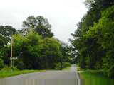
 Today the themes were antiques, flowers and history. Left La Grange an
hour later than normal due to the time change. Keeping with the sun and
not the clock. Each morning get up a few minutes earlier due to my
eastward progress and due to lengthening days.
Today the themes were antiques, flowers and history. Left La Grange an
hour later than normal due to the time change. Keeping with the sun and
not the clock. Each morning get up a few minutes earlier due to my
eastward progress and due to lengthening days.
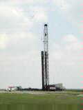
Still signs of energy development in the La Grange area. Several places
where they were drilling for oil and also some gas pipelines. Leaving
town, waited for a long coal train to clear the tracks.
The entire route along the way had many historical plaques relating to the
war for Texas Independence from Mexico and original settlement of the
area. Much of this area was settled by German settlers and their
descendents still have many German names and Lutheran churches.
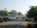
 Antique
week! As I came to Oldenburg, the antique tents started. Lots of old
junk and other knickknacks to purchase. At Warrenton, both sides of the
street had booths. Parking was up to $5. Fortunately, still early
and not too many people on the road.
Antique
week! As I came to Oldenburg, the antique tents started. Lots of old
junk and other knickknacks to purchase. At Warrenton, both sides of the
street had booths. Parking was up to $5. Fortunately, still early
and not too many people on the road.
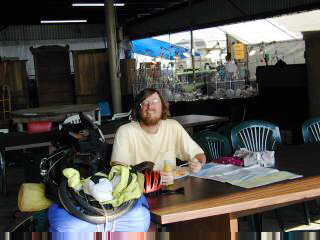
Stopped at one of the antique fair that had a restaurant. Picture above
left taken there. Outside the restaurant were several plastic bags filled
with water and nailed to the walls. Apparently, the lore is that this
remedy blinds the flies.
Out of Warrenton, the antiques decreased some as came through Round Top and
merged onto busy US 290. Fortunately nice wide shoulders before an exit at
Burton. Here I took TX 390, a small "scenic" highway. The
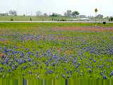
next thirty miles zigged and zagged though an area with many small farms and
also many bluebonnet flowers. A surprising number of Sunday
drivers...mostly "flower people" coming for bluebonnets. Lots of
convertibles, motorcycles, vans full of people driving slowly. Also, a
pack of humvees. Slowly made my way through Long Point, Gay Hill,
Independence and William Penn. All except Independence were too small to
have much business.
Also on this route was the original site of Baylor University, with a
beautiful field of flowers and also some nice historical exhibits.
 After
the flower route, merged back onto TX 105 for last 17 miles to Navasota.
This included a brief detour to Washington on Brazos, the site of the Texas
declaration of independence and also the capital of Texas for a while.
Nice visitor center here.
After
the flower route, merged back onto TX 105 for last 17 miles to Navasota.
This included a brief detour to Washington on Brazos, the site of the Texas
declaration of independence and also the capital of Texas for a while.
Nice visitor center here.
Navasota marked end of the next Adventure Cycling map. Now time to
study the next map and figure out the route for the next week or so.
74 miles today, 2207 miles cumulative.
April
2nd; Navasota to Coldspring
 Trees and forest today. Overcast skies and southerly winds starting
out. However, wind made much less difference here with lots of trees to
block the wind. Rolling hills through to Anderson where took off on
smaller roads through Richards then across Lake Conroe to New Waverly.
Trees and forest today. Overcast skies and southerly winds starting
out. However, wind made much less difference here with lots of trees to
block the wind. Rolling hills through to Anderson where took off on
smaller roads through Richards then across Lake Conroe to New Waverly.
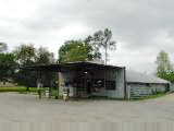
Stopped at the Richards cafe. Clerk was kind enough to make some
breakfast for me. They see occasional touring cyclists here with the
Adventure Cycling route coming through. East of Richards went into the Sam
Houston National Forest. Mostly pine trees, with some burn areas visible
at 149/1375 cutoff. Still an occasional farm, but also a lot more run-down
houses and trailers.
Nice broad shoulder when crossing Lake Conroe. A few boats out on the
water. Lunch in New Waverly cafe before some winding hills via Pumpkin and
Evergreen to Coldspring. Discovered my tire had been rubbing, so much
smoother when I fixed that up. Also surprised to see at least four or five
small cemeteries marked along the way. Still early, but limited set of accommodations
so a stop for the day.
I've finally started seeing indications of "East Texas".
Seems like "West Texas" stretched at least to Austin, so nice to get
an acknowledgement that I'm getting closer to the LA border. Music
for today.
66 miles today, 2273 miles cumulative.
April
3rd; Coldspring to Silsbee
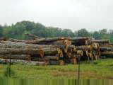
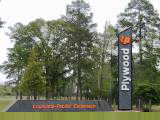
 Today riding into and through the thicket. This region has dense trees
and undergrowth. Quite a few logging trucks along the way. Also
trucks with completed boards and sawdust. Didn't see any big mills or any
clear direction to the trucks though.
Today riding into and through the thicket. This region has dense trees
and undergrowth. Quite a few logging trucks along the way. Also
trucks with completed boards and sawdust. Didn't see any big mills or any
clear direction to the trucks though.
Hot and humid starting out. This area must get completely unbearable in
the summer. Flat terrain. Contour intervals on the map are 100ft, as
compared to 1000ft in the western maps. Even then, not many contours to
cross. Stopped in Shepherd at a newly expanded supermarket before crossing
US 59 and taking small back roads past Dolen, Romayer, Votaw, Thicket and Honey
Island. Each of these places very small, typically with a church or two
but not other establishments. Shoulders intermittent but light
traffic. Even logging trucks were good about moving out of the way.
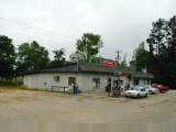
 Stopped
in Honey Island for lunch. Small feed store and cafe. Food for both
people and cows. The mineral supplements, oats and other grains were out
back and the grill was up front.
Stopped
in Honey Island for lunch. Small feed store and cafe. Food for both
people and cows. The mineral supplements, oats and other grains were out
back and the grill was up front.
After Honey Island, busier traffic through Kountze and then into Silsbee.
70 miles today, 2343 miles cumulative.
April
4th; Silsbee to DeRidder
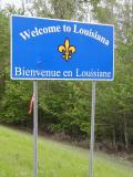 Steamy spring cycling today. They start to report a "heat
index" here, so know it can get warm. More timber in this area as
picture above left shows. Also notice from picture above right, that
crossed into LA after about 50 miles of riding. Yipee! Now have
cycled in 42 states (not all on this trip) and am missing: UT, OK, KS, MO, AR,
IN, KY and WV so no more on this ride.
Steamy spring cycling today. They start to report a "heat
index" here, so know it can get warm. More timber in this area as
picture above left shows. Also notice from picture above right, that
crossed into LA after about 50 miles of riding. Yipee! Now have
cycled in 42 states (not all on this trip) and am missing: UT, OK, KS, MO, AR,
IN, KY and WV so no more on this ride.
First thirty miles was along the large US 96 from Silsbee up to
Kirbyville. Fortunately, most of this route had a six-foot shoulder,
though in the small stretches that didn't the trucks let me know with their
horns. Not certain they have as many cyclists out here. Hot and
humid and even a bit of warm mist as I cycled along. Not certain of how to
dress for this, but decided to go for visibility with my bright yellow
jacket. Definitely a sauna in this heat and humidity and now only April!
From Kirbyville, back on the Adventure Cycling route and through the
thicket. This area continued with lots of signs of lumber...log trucks,
mills and some reforested trees. Not much in shoulders, but also not very
heavy traffic. I saw one "East Texas Catfish" sign, but
surprisingly, it seems there is very little "East Texas".
Previous evening even had "West Texas BBQ", so seems like all of Texas
wants to be associated with "West".
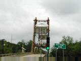
Crossed the Sabine River and into Louisiana! Yeah! Texas seems to
have a succession of important rivers: Rio Grande, Pecos, Guadalupe, Colorado,
Brazos, Trinity and finally the Sabine. These rivers all have fair amount
of water, though seems like a bit muddy to drink.
Just outside Merryville about four miles into Louisiana, met a couple touring
on a tandem. They had started in Miami and were headed towards San
Diego. From there, back to Florida and then up the Atlantic Coast.
Including a previous trip, this would complete a perimeter of the USA. We
traded road information including some cautions received about cycling in
Louisiana. Nice to see some other long-haul cyclists out there.
Still forests, but also some cleared lands in LA as cycled through Merryville
and then slowly into the bigger city of DeRidder. Surprising amounts of
traffic for a smaller town here. Music
for today (Louisiana anthem).
71 miles today, 2414 miles cumulative.
April
5th; DeRidder to Opelousas
 Country backroads today through western Louisiana. DeRidder still with
busy traffic in morning starting out. However, after leaving US 190, four
miles into the day, much less traffic. Still some woods and log trucks as
shown above left. However, much more farmland today. Some wheat and
other grains, but also a lot of rice. Entire fields were flooded and
surrounded with low dikes to keep the water in.
Country backroads today through western Louisiana. DeRidder still with
busy traffic in morning starting out. However, after leaving US 190, four
miles into the day, much less traffic. Still some woods and log trucks as
shown above left. However, much more farmland today. Some wheat and
other grains, but also a lot of rice. Entire fields were flooded and
surrounded with low dikes to keep the water in.
Flat terrain cycling through small backwoods including towns of Wye, Mittie
and to Oberlin at mile 37. Quite a ew Pentecostal churches. Oberlin
was small town of ~1000 with a cute main street. Signs for a casino, but
didn't see one close by. Saw signs for 7 miles of road construction so
stopped for a late breakfast. Fortunately, construction better than
expected, even with smooth newly paved roads. More quiet roads except for
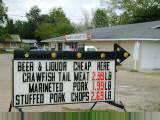
small town of Mamou.
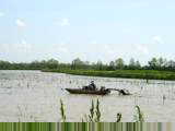
 Picture
at left shows boat patrolling small pond. Not clear whether this was more
rice or a catfish pond? Also noticed that several places had steady
sequence of boom, boom sounds, perhaps to keep birds away.
Picture
at left shows boat patrolling small pond. Not clear whether this was more
rice or a catfish pond? Also noticed that several places had steady
sequence of boom, boom sounds, perhaps to keep birds away.
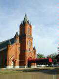
Last few miles tried a short stretch on US 190 to see whether it would make
sense to take US 190 to Baton Rouge or use the more roundabout Adventure Cycling
route. Picture above right shows Catholic Church near the end of the day.
85 miles today, 2499 miles cumulative.
April 6th; Opelousas to St. Francisville
Today a day for a shortcut. The normal Adventure Cycling route is ~110
miles from Opelousas via Simmesport to St. Francisville. My maps showed LA
10 almost 50 miles shorter. Even shorter would be US 190 direct to Baton
Rouge...however, I wanted to avoid the big city on a weekday. The map did
show a five mile section with road markings not listed on the legend.
Gravel perhaps?
When taking a new route like this, my standard practice is to ask several
different people about the route. Motorist descriptions of good roads for
cycling vary...but with several opinions, can average things out. First
time asked at Washington about five miles out, "the road becomes very
rural, but stays a good road from Melville to Morganza...". Stopped
for breakfast in Lebeau and heard, "...there was some construction a while
ago, but still a good paved road".
The route from Lebeau was rural. Farming areas mostly gave way to
swamps, some listed with hunting signs, but not much else. Peaceful road
without much traffic. The route paralleled the railroad tracks. At
Palmetto, I passed a train that slowed and stopped on the tracks.
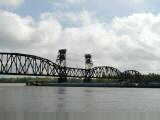
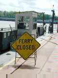
On reaching Melville, I got a surprise none of my motorist consultants had
told me about. A broad channel, the Atchafalaya channel. Apparently,
one of the primary ship channels to go from the Mississippi westbound. Saw
signs for a ferry, but then found out ferry hours only from 5am-8am and
4pm-9pm...oops, at 10am, I'd have a while to wait for the next ferry.
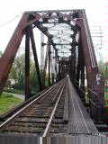
As I contemplated what to do...wait six hours or detour 50+ miles..., I
noticed the railroad bridge had a small pedestrian walkway. Perhaps
possible to walk across the bridge. I started walking and had just passed
a small building on the bridge when someone came from the building and called to
me. Uh, oh...was he sending me back? I couldn't hear, but walked
back to where he was. "There is a train coming, you better put your
bike in here while it goes past..." As we chatted briefly, found out
that I was far from the first bicyclist trying this shortcut over the
bridge. After the train came past, he was kind enough to let me complete
my walk across the Atchafalaya.
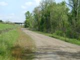
Once across, came off the levee and lifted my bike over the barb wire
fence. Oops, looks like this road was gravel. It paralleled the
levee and not quite clear which direction to find LA 10. Fortunately, a
passing truck gave me a pointer and I headed off for five miles of gravel road.
 Pavement!
Yes, felt good to reach pavement and get rolling a bit quicker. Continued
past farming areas before stopping in Morganza for lunch. From there an
easier ride along LA 1 and reaching the next ferry across the Mississippi.
Fortunately, this one goes continuously between 4:30am and 11:45pm.
Pavement!
Yes, felt good to reach pavement and get rolling a bit quicker. Continued
past farming areas before stopping in Morganza for lunch. From there an
easier ride along LA 1 and reaching the next ferry across the Mississippi.
Fortunately, this one goes continuously between 4:30am and 11:45pm.
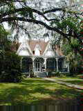
After leaving the ferry, came through quaint town of St. Francisville.
Many historic houses, with lots of plaques telling of the town. Stopped in
at the museum and found the town had once been second largest (after New
Orleans) in these parts and also a place with many country plantation
estates. Stopped at the St. Francisville
Inn, a B&B in town.
62 miles today, 2561 miles cumulative.
April
7th; St. Francisville to Hammond
 Tough riding conditions today through Baton Rouge. Biggest city since
El Paso.
Tough riding conditions today through Baton Rouge. Biggest city since
El Paso.
A nice breakfast at the inn and time to get on the road. US 61 had nice
shoulders with a few gentle rolling hills as headed south towards Baton
Rouge. A few plantations along the way and slowly increasing traffic as
got closer to Baton Rouge. Shoulder fine, except for where it crossed
bridges and went away.
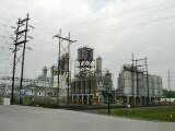
At 23 miles, entered the city of Baton Rouge and shoulder disappeared briefly
with busy traffic entering I-110. Not a pretty city, as can be seen from
industrial plant shown above left. Fortunately, after the I-110 cutoff,
less traffic. Rode past the US 190/US 61 junction and made my way through
city streets and poorer neighborhoods to east part of town. Here a long
"strip" named Florida Boulevard with lots of businesses and lights not
quite timed for bicycle speeds.
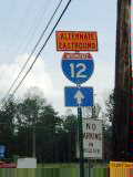 East
of town on US 190, came the challenging riding. US 190 parallels
I-12. Unfortunately, construction on I-12 was directing some of the
eastbound traffic onto US 190. In addition, for most of the next 25 miles,
the shoulders were not paved. This meant careful riding on just the right
side of the lane with lots of traffic whizzing by. It was actually easier
riding within city limits of some of the small towns like Walker, Livingston,
Holden and Albany both because speeds were decreased and because there
frequently was a shoulder. Most of the vehicles were fine and gave as much
room as they could. Still took a bit of concentration watching for the 1%
of drivers not quite with it...I was pleased to see the shoulder reappear at
Albany, and also to see the detour I-12 signs go away at Hammond. Still
enough riding for the day.
East
of town on US 190, came the challenging riding. US 190 parallels
I-12. Unfortunately, construction on I-12 was directing some of the
eastbound traffic onto US 190. In addition, for most of the next 25 miles,
the shoulders were not paved. This meant careful riding on just the right
side of the lane with lots of traffic whizzing by. It was actually easier
riding within city limits of some of the small towns like Walker, Livingston,
Holden and Albany both because speeds were decreased and because there
frequently was a shoulder. Most of the vehicles were fine and gave as much
room as they could. Still took a bit of concentration watching for the 1%
of drivers not quite with it...I was pleased to see the shoulder reappear at
Albany, and also to see the detour I-12 signs go away at Hammond. Still
enough riding for the day.
Somewhere around the Mississippi River, I've passed the point where I am much
further than half way. One common question is "where are you coming
from" and also "where are you going to". As recent as
western LA, folks would remark in a way that indicated they thought Florida was
at least as far as California. However, now since Baton Rouge, that has
changed. Still a ways to go, but getting closer. Music
for today
65 miles today, 2626 miles cumulative.
April
8th; Hammond to Bay Saint Louis
 Better riding today. Wide shoulders from Hammond to Robert. After
that shoulders disappeared, but still light traffic. Mostly wooded and
quiet. Passed a prison with sign, "Do not pick up hitchhikers"
and then also a hospital with the same, "Do not pick up hitchhikers"
sign. Despite lack of shoulders, very little traffic in to Covington.
Better riding today. Wide shoulders from Hammond to Robert. After
that shoulders disappeared, but still light traffic. Mostly wooded and
quiet. Passed a prison with sign, "Do not pick up hitchhikers"
and then also a hospital with the same, "Do not pick up hitchhikers"
sign. Despite lack of shoulders, very little traffic in to Covington.
At Covington, quite a few signs about "North Shore", apparently a
commuting area from here across Lake Pontchartrain to New Orleans. Also a
few signs about Ponchatoula strawberries. Still a few crayfish and shrimp
signs. Road was larger and busier coming through Mandeville and then
quieter heading towards Slidell.
Roadkill this past week has included armadillos, opossums, frogs and
snakes. Also notice people have metal enclosures for their trash, so
apparently a few critters out there to keep from the trash.
I had heard bad things about road conditions in Slidell, so was positively
surprised. Still not wonderful, but better than expected. Here the
route wound through and then southbound towards US 90. US 90 had shoulders
for the first four miles to the MS border. This region crossed a swampy
region.
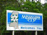
 Crossed
the East Pearl River and was in Mississippi! Yeah! Typically, there
is a sign at the line, but the first "Mississippi" sign was the one
left for loans. About a mile later, saw the official sign. This area
still quiet and shoulders went away again. Also a several mile stretch of
obnoxious jarring cracks every 15ft. No real businesses until
reached Waveland. Stopped in Bay Saint Louis, not too far from the gulf
beaches though that will have to wait until tomorrow. Music
for today (Mississippi anthem). Apparently just missed "Black
Spring Break", 90,000 revelers this past weekend and 166 arrests.
Crossed
the East Pearl River and was in Mississippi! Yeah! Typically, there
is a sign at the line, but the first "Mississippi" sign was the one
left for loans. About a mile later, saw the official sign. This area
still quiet and shoulders went away again. Also a several mile stretch of
obnoxious jarring cracks every 15ft. No real businesses until
reached Waveland. Stopped in Bay Saint Louis, not too far from the gulf
beaches though that will have to wait until tomorrow. Music
for today (Mississippi anthem). Apparently just missed "Black
Spring Break", 90,000 revelers this past weekend and 166 arrests.
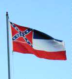 There
is a referendum on April 17th, whether Mississippi should change it state flag
to replace the confederate stars and bars with a circle of 20 stars. After
Georgia recently changed its flag, Mississippi is the last with the confederate
symbol as part of its flag. Poll numbers suggest 67% in favor of the
current flag and 22% in favor of a new flag.
There
is a referendum on April 17th, whether Mississippi should change it state flag
to replace the confederate stars and bars with a circle of 20 stars. After
Georgia recently changed its flag, Mississippi is the last with the confederate
symbol as part of its flag. Poll numbers suggest 67% in favor of the
current flag and 22% in favor of a new flag.
80 miles today, 2706 miles cumulative.
April
9th; Bay Saint Louis to Bayou La Batre
 Followed US 90 along the Mississippi coast today. Coming out of Bay
Saint Louis was a long bridge across the bay. Halfway across one lane was
closed down for construction. Jersey barriers squeezed the remaining lane
so narrow that cars couldn't pass, so I got up on sidewalk and walked the
remaining mile across the bay. Stopped briefly in Pass Christian with nice
harbor shown above left.
Followed US 90 along the Mississippi coast today. Coming out of Bay
Saint Louis was a long bridge across the bay. Halfway across one lane was
closed down for construction. Jersey barriers squeezed the remaining lane
so narrow that cars couldn't pass, so I got up on sidewalk and walked the
remaining mile across the bay. Stopped briefly in Pass Christian with nice
harbor shown above left.
US 90 was two lanes with no shoulder, but reasonable traffic. As I got
closer to Gulfport and Biloxi, I saw signs from the party the weekend
before. Apparently, more than 400 police vigorously enforced keeping the
left lane for emergency vehicles and having the right lane be a slow moving
gridlock with stopped cars quickly towed...more than 600 tows in all. The
towns proclaimed this vigorous enforcement a success (in comparison to 2000 when
the highway completely shut down). Some of the partiers had stories in
papers about overly aggressive enforcement.
Gulfport and Biloxi had half a dozen casinos between them. Pretty white
beaches to the right of the highway and beach businesses along the way.
Also a marine aquarium. From Biloxi crossed another causeway and into
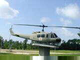
Ocean Springs. At Ocean Springs, a memorial for Mississippi Vietnam
Veterans with the helicopter shown above left. Quieter traffic leaving
town.
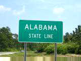 Busier
into Pascagoula with lots of strip mall businesses leaving town. Also two
miles of road construction again. After the businesses, a few alligator
farms and then quiet woods. A quick bend in the road and the sign at left
indicating Alabama state line.
Busier
into Pascagoula with lots of strip mall businesses leaving town. Also two
miles of road construction again. After the businesses, a few alligator
farms and then quiet woods. A quick bend in the road and the sign at left
indicating Alabama state line.
Four miles later, the small town of Grand Bay and reached the Adventure
Cycling route again. Followed it on AL 188 for nine miles to Bayou La
Batre. Quieter road with some farms along the way. Music
for today (Alabama anthem).
67 miles today, 2773 miles cumulative.
April
10th; Bayou La Batre to Gulf Beach
 Today crossed over Mobile Bay and made it on to Florida. Pleasant
cycling from Bayou La Batre past mostly wooded terrain, with some swampy
areas. Saw a large "antenna farm" on the south, not certain what
that was. Stopped briefly in Alabama Port at the aptly named Corner Store
before heading southwards past Cedar Point. Stopped briefly and discovered
one of the bolts holding my rear fender had fallen off, causing occasional extra
friction. In hindsight, perhaps for the last 100+ miles.
Today crossed over Mobile Bay and made it on to Florida. Pleasant
cycling from Bayou La Batre past mostly wooded terrain, with some swampy
areas. Saw a large "antenna farm" on the south, not certain what
that was. Stopped briefly in Alabama Port at the aptly named Corner Store
before heading southwards past Cedar Point. Stopped briefly and discovered
one of the bolts holding my rear fender had fallen off, causing occasional extra
friction. In hindsight, perhaps for the last 100+ miles.
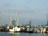
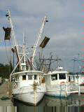
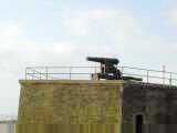
On the way to Cedar Point, several small oyster boats. Above left are
shrimp boats and boat on left is even for sale! Crossed the causeway and
made it to Dauphin Island. Looks like a quiet little island with mostly
vacation homes. On one end, Fort Gaines with the cannon shown above
right. Also an "Estuarium". Both the Fort and Estuarium
not open for business yet, so read the Mobile paper while waiting for the 9:30am
ferry. Met several nice folks while waiting and on the ferry, the loaded
bike stands out a bit.
Half an hour ferry and $3 ride across to Fort Morgan. In the bay were
at least half a dozen oil/gas platforms. Just off the ferry, a local group
was conducting a "bird banding". For two weeks each spring and
each fall, this group catches migrating neo-tropical birds and places
bands. Several thousand birds are banded each year. They have a
small information tent and inform the public about their efforts and about
decreasing habitats affecting migrating birds. No birds to band while I
was there. South winds mean the birds more likely overfly the barrier
islands and keep going. They did tell me about a cottonmouth snake caught that morning
and released out of the immediate area.
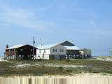
 Near
Fort Morgan, a number of beach houses up on stilts. Apparently, ~$300,000
and up for a house right on the beach. Stopped briefly at a place selling
beach food including boiled peanuts and then several miles down the road a
combination hardware/convenience store. Great!, was able to find a
replacement bolt for the fender and some lunch for me.
Near
Fort Morgan, a number of beach houses up on stilts. Apparently, ~$300,000
and up for a house right on the beach. Stopped briefly at a place selling
beach food including boiled peanuts and then several miles down the road a
combination hardware/convenience store. Great!, was able to find a
replacement bolt for the fender and some lunch for me.
Quiet riding again for next ten miles past Bon Secour Wildlife Refuge and
then into the busier city of Gulf Shores. Motels, restaurants, beach
stores, water parks and quite a few condos in the next stretch of
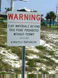
beachfront. Entered the next town of Orange Beach which had a sign,
"Clay Materials Beyond This Point Prohibited Without Permit".
The sign was curious enough that I stopped at the next visitor information
center and asked (also a good excuse for a break). They explained that the
town wanted to preserve the white sandy beaches and thus was regulating
landscaping including red clays.
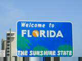 Orange
Beach still a busy town, but nice bike lane along the way. Climbed over a
bridge and not too much further saw the Florida sign. Hooray! Still
have a ways to go along the panhandle, but nice to get to the last state of this
part of the trip. Four different states the past four nights.
Continued pleasant riding in Florida, but decided to stop seven miles further at
the first motel on the route. Music
for today (Florida anthem).
Orange
Beach still a busy town, but nice bike lane along the way. Climbed over a
bridge and not too much further saw the Florida sign. Hooray! Still
have a ways to go along the panhandle, but nice to get to the last state of this
part of the trip. Four different states the past four nights.
Continued pleasant riding in Florida, but decided to stop seven miles further at
the first motel on the route. Music
for today (Florida anthem).
60 miles today, 2833 miles cumulative.