Bicycling from El Paso to Santa Fe
April 2025 and time for another bicycle trip. This time I decided to take a week of vacation to bicycle in New Mexico. I have a condo in Alto (near Ruidoso) and planned trip with that in mind. In particular (a) I picked a route via Ruidoso so I can switch out gear and (b) I brought my work laptop so I can work remotely in the week immediately following.
April is an OK time for such a trip. Summer temperatures make the lower elevations and deserts unpredictable for a summer trip. It is the windiest time of the year, but the winds come from South/West more often than other directions so a good chance at some tailwinds. I built some slack in the schedule so I could wait out a short-term adverse weather event.
On Thursday, April 3rd I rented a minivan, loaded it up and took off after work. Only 100 miles to Brady, TX but I like getting the trip started on the road rather than early the next morning. Friday was a “recharge day” so no meetings and employees are encouraged to take off (but with pay). A nice perk and in my case it gave me an extra day for riding.
Friday morning I was on the road and reached my condo around 3pm. I had brought with me three bicycles. One was a mountain bike I normally have there but had moved to Austin in Fall 2024. I also brought a new Kona Sutra bike I purchased at start of the year. I only had a front rack on it so could carry enough for staying in motels but not quite enough if I also wanted a contingency for camping. The final bike was my Trek 520, a trusty bike with front and rear panniers.
The plan was to start off with the Kona Sutra from El Paso to Ruidoso – and probably the Trek 520 from Ruidoso to Santa Fe. This way I would get some more extended time on each bike and could better compare them from touring perspective.
Below is the starting picture at the El Paso Airport. I arrived a little before sunset so this let me drop off the rental car, load my bike and ride a very short distance to the airport hotel.

El Paso to Las Cruces (57 miles)
In the days before starting, I had checked the weather multiple times. There was a cold front coming through. Further north in New Mexico and even in Ruidoso this meant snow in the forecast. In El Paso it was more showers. What was more important was the direction and speed of the wind. From El Paso to Alamogordo I had two choices:
- The more direct route was ~85 miles mostly NNE on US 54. There was one small settlement (Orogrande) where I could probably camp but otherwise not much choice. With a headwind or strong crosswind, 85 miles would be miserable but with a tailwind it could be fun.
- The indirect route was ~55 miles from El Paso to Las Cruces and then ~65 miles from Las Cruces to Alamogordo. The section from Las Cruces to Alamogordo also went through wide open desert but at least was 20 miles shorter.
In the end, the weather forecast told me ENE winds strengthening during the day and somewhere between 0.05 and 0.25 inches of rain. Taking two days also make later days a bit warmer and still favorable for wind. So I decided to take the Kona Sutra, no camping gear but go in two days via Las Cruces.
Many motels in Texas have waffle makers and often in the shape of the state. So my breakfast included a Texas waffle.

It was overcast but dry and there was a moderate wind from the east. If it was windy this early in the morning, I was glad I made my route choice. There were some rolling hills including this spot where I looked over some of the city. The airport is in the east and I went around a ridge of mountains to follow the Rio Grande River valley.

The photo below was ~13 miles in where I had reached US 85 and right close to the river. There was construction here and the road was officially closed but I was able to bicycle past. After this a short section of bike path and then a straight but road with a moderate amount of traffic as I headed north through El Paso. At 16 miles, I took a short stop at a convenience store for a snack and then back on the busy road.

At 22 miles I reached the state line. By now traffic was less and until Las Cruces it was more of a quiet road along orchards. I saw multiple groups of Saturday morning bicyclists though they all seemed to be going the other direction. I also met two cyclists who were going coast to coast on the “southern tier” route. I had also bicycled this same route in 2001 so it was nice to be back where I had cycled before.

Examples of these pecan trees. I was surprised they were just now starting to get leaves.

One village had a huge cell tower. I think it was supposed to be disguised as a tree. However, the disguise wasn’t very convincing since it was much taller than any other tree in the area.

Small catholic church in La Mesa. I had the same picture in 2001 here

After La Mesa it gradually got busier again and I went through Mesilla and then across I-10 through middle of Las Cruces and then across I-25 and close to US 70. Overall a nice ride. Temperatures never got much over 50F but there wasn’t much rain. This let me get to the motel and relax in getting ready for the next day.
Las Cruces to Alamogordo (63 miles)
Today was a nice ride across the Tularosa Valley. Most all the climbing was in the first 13 miles. After that calm winds and mostly flat. The profile was expanded to fit the screen so it wasn’t as steep as implied. Close to the top were a few places with 7% grade. I was in my lowest gear. I’m glad I don’t have a rear rack on this bike as the extra weight would make the low gearing not quite enough.

Pretty much the entire route was along US 70 first along the frontage roads. There was a steady grade. Sometimes a bike lane but also sometimes some glass in the lane. The morning started out just below freezing so it was nice to generate heat while climbing.

As I passed a space/missile museum I then joined the main highway and the grade also got steeper. The last five miles varied between 5% and 7% sections.

After 13 miles I reached the top. San Agustin Pass

There was a wildlife refuge here with some displays and a large missile statue


From here a relatively quick descent until I came past the entrance to White Sands Missile Range at 20 miles. After this a steady ride along the floor of the valley without much variation in altitude.

US 70 was a divided highway with four lanes but the shoulder was reasonable and traffic gave me enough room. Signs all prohibited any access to smaller roads.

As I got close to 45 miles I saw some of the dunes from White Sands National Park.

I stopped at the visitor center to eat a sandwich I had brought with me but didn’t go further into the park. I’ve been there before and was happy to keep going after my late lunch.

Without too much difficulty, I made it to Alamogordo and to a motel I had reserved in advance. Nice chance to rest and get ready for the next day.

Alamogordo to Alto (56 miles)
Today was a day for climbing. The first 13 miles were flat to Tularosa but from there 26 miles and 3000ft of climb to the top of Apache Summit. After that a descent into Ruidoso and then another 1000+ft of climb to Alto. My cycle computer recorded 4629ft of climb.
I had done this same ride a year ago and had ~2 inches of snow at the summit. So a much better set of weather for today. Slightly cool at the start but it quickly warmed up after that. All this was familiar area from other cycling as well as visiting in the area.
After leaving Alamogordo, I came past the giant pistachio and an obligatory photo.

I stopped at the Chisolm gas station outside Tularosa at 13 miles. Got a few things to eat and shortly thereafter started the climb. US 70 is a divided highway with a good shoulder. The grades were also reasonable and steady so a good road to climb on.

Catholic Church near Bent NM

I measured my progress by keeping track of elevation. At 6500ft was a more general area with school and store. This was a good stop to get some lunch.

Another 1100ft of climb brought me to the summit. I have now brought three different bicycles to this summit point.

Ate a banana and threw away the peal in the dumpster. Thought the scarecrow on the fence was interesting. A way to ward off illegal dumping?

From here 8.5 miles of descent and down into Ruidoso. Mountain ahead is Sierra Blanca and the information sign also describes the peak.

After a late lunch, I took the local roads up from Ruidoso to Alto. Alto is a small unincorporated area so for outsiders I’ll also mention “Ruidoso” as general location but in this case it mattered since I was climbing. Close to the top is a section with ~10% grades and I took a short section to walk this uphill. I also crossed this burn areas below.

Not sure what that fuzzy thing was in front of the lens, but I was happy to reach my destination.

From here started working the next set of reservations. I had sent an email to the motel in Corona but not heard from them. So decided to call and got voicemail that all their rooms were full. So I left a message for wait list. In any case, I’ll also need to bring my tent and camping gear for the next section just in case I don’t have a place in Corona.
Alto to Carrizozo (26 miles)
Today was a shorter easier day. The next two places along the way were Carrizozo (27 miles) and Corona (73 miles). While I could probably make it to Corona in a day, that would be a long ride and not leave too much margin for wind. This also let me dial into work, attend two meetings and catch up with my email. I didn’t want to arrive too early so didn’t leave Alto until 11:30am.
The ride to Carrizozo had 3000+ feet of descent and only 1000+ feet of climb. There were a few stretches of 8% grade but overall this also made it somewhat easier.

For this next stretch, I decided to swap bikes and instead take my heavier touring bike. This meant I could take my camping gear. I didn’t expect to get a motel room in Corona and otherwise there wasn’t as much margin. The bike felt comfortable and rode slightly different from the Kona Sutra. Most importantly, it had some lower gears so I could both carry more and also very slowly ride up the steepest hills if I needed. Below is the photo at the Chisum store just at departure.

There was some descent and climb right away, particularly down an 8% grade for two miles. After that it climbed back up some and hovered back around 7000ft for a while before descending steeply again into settlement of Nogal shown below. There was a strong wind coming from the WSW and as I got past Nogal, it seemed like it picked up some. Nogal itself was at 6500ft so still 1000ft to descend after that.
As I was riding, the motel sent me an email. There had been a mixup and they didn’t have a room for me after all. Not too much else to do – but ride down to Carrizozo and check things out. There were three motels in town and I had reserved at the only one where I could online (via booking.com); the other two had fewer reviews on Google so I wasn’t sure.

At 19 miles I reached the intersection of US 380. The last eight miles from here had a solid headwind combined with a slight descent. It was still some work riding into the wind but I was happy with shorter ride.

I reached Carrizozo a little before three. I went to the motel that had cancelled but there was a note and phone number on the door. So instead I went across the street to Carrizozo Inn. Just as I was there, one of the cleaning staff came up. She didn’t speak English but was able to call the owner. He told her to open a room and he would come by in an hour or so and settle up.
That was appreciated and I was happy to have a room. I never did get a room key or the wifi password but otherwise a nice place to stay. Out of the wind and a good rest for what I expected would be a tougher ride the next day.

Carrizozo to Corona (52 miles)
Today was only 47 miles but there was a chance of stronger cross-winds later in the day so I was on the road not too long after sunrise. Corona would be the only stopping point so had some snacks and water along the way.
The day started out beautiful, calm and sunny. There were no turns today so everything on US-54.

At 20 miles came the only side road – NM 55 going off to Mountair. 62 miles down the road and perhaps a chance at lodging? Though nothing online. I briefly paused but in the end decided to stick with the original plan. In hindsight this turned out good since I would have found myself rationing water since I brought enough for Corona but not for this extra distance.

Two miles later an entrance to Windmill Ranch. After this point, I started getting some wind. Fortunately, mostly a cross wind and hence wasn’t a big issue.

There is a block of construction starting after mile 27. I have driven this route multiple times, most recently in January 2025 but wasn’t sure what I would find this time.

The first miles were good and still kept a shoulder on the right side. There was a steeper climb for a mile or so where I switched to the left side since it had more room.

When I got to the top the original road was still narrow without much of a shoulder. Not in photo below but there would be convoys of trucks/cars coming past so that could be obnoxious. However, to the right they were getting close to done. The road went from pavement to oiled gravel to smoothed gravel and finally to rough. For multiple miles and most of the distance I was able to avoid the narrow original road by cycling on the not yet open sections.

All this brought me to Corona by 1:30 pm or so.

The first order of business was to go to the motel. There was an adjacent general store and I talked with the motel owner there. They hadn’t responded to my email or voicemail. Their outgoing phone message said they had no room but leave a message to get on a wait list.
So I asked the likelihood of a wait list. They said none – they had rented their rooms during the week to workers on a nearby wind farm. Between the wind farm and construction nearby pretty much everything was full. They did have an RV park with bathroom and shower and I could camp there if needed.

They had a fun old phone booth

I hung around town for a few hours, got a bite to eat and read my Kindle book. It was a relaxed afternoon. After that I loaded up on some extra water and some food and left around 4pm to ride a few miles out of town where iOverlander had indicated there was a national forest where some had camped. Four miles down the road I found the entrance.

Half a mile further I found a spot on the left side and got behind the trees and set up my tent.
It was a nice campsite. The sun warmed my tent. The moon came bright the first part of the night. There was a travel trailer nearby and the owner came in right around sunset and started a generator that went all night. Not too bad of a hum and they left just a bit before sunrise. So a nice ride overall.

Not too far in this area were also some of the tall wind towers.

Corona to Moriarty (64 miles)
Today was a flat ride though slightly longer than average. I woke up well rested in my hidden campsite. It was a cool morning but quickly warmed up in the morning. There were some wide open spaces and I was happy to have no wind.

My first place along the way was Cedarville. It was pretty much remnants of a town. Seems hardy for pinto beans to grow in this area – and also hardy to have folks homesteading here.

Behind the Cedarville sign you can see one of the run down buildings.

At mile 13 was a roadside picnic table. There was some glass around and looked like some people had hopped the fence. I was happy with my campsite and glad I didn’t decide to continue and try camping here. I didn’t see any “no camping” signs but it was narrow to the fence and likely private property across the fence.

At 20 miles I noticed something on my Google Map, a marker for “Geographic Center of New Mexico”, looked like less than a mile off the road (though it turned out to be 1.5 miles each direction). I had some time and seemed like an interesting place to explore – so first down this road.

I reached a ranch house about 0.7 miles down this road and then there was a separate path to go from there. Eventually made my way to a flagpole and a small enclosed gate.


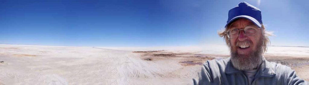
I stepped back and took a panorama photo so you can see how sparse and wide open this otherwise is. You can see the flagpole about a third of the way into the panorama and otherwise wide open country.

After this back to the main road and then to Willard where I was there by 11:30am and hence just in time for lunch at the cafe.

After lunch the road turned more north and slightly into the wind but fortunately not too strong. Estancia was 13 miles later and largest town.

Some motorcycles coming into Estancia.

After Estancia the shoulder gradually become wider and there was also more traffic. Not sure what this “What About Us” sign meant. Overall, reached Moriarty about 3:30pm so was a nice ride and finish to the day. Also good to get a bed and a shower again.

Moriarty to Santa Fe (52 miles)
Today was the last day riding and completion in Santa Fe. I found my way to a motel about five miles west of town center – and also near the airport and car rental place. I actually gave myself eight days to ride so will have a free day tomorrow to do some shorter riding around Santa Fe and get to more official places.
Moriarty is a roadside stop along I-40 with plenty of motels and roadside business. Also some signs for historic Route 66. Each day this week had been getting slightly warmer and this afternoon was warm but still reasonable. Hence, April was a good time to do this ride as two months from now would have more risk of rather hot temperatures.
After crossing the Interstate it quickly became wide open country again. There were even some farms including some center-pivot sprinklers. The road was mostly flat with a shoulder.

After a very gradual ride as the land followed a wide area up, I reached ~6600ft and more change in landscape with some slight hills. From this point at mile 17 to Galisteo at mile 28.5 I dropped ~500ft but also came over some lower hills as well. There wasn’t much traffic on this road though I did see a rider pass me – and likely turn around at Galisteo since he then came back the other direction.

Galisteo had this church at main intersection of town. Otherwise didn’t see any business.

Historic marker.

The next 9.3 miles were on a smaller road with some steeper climbs and drops.

There was unfortunately also a ghost bike along the way. At a turn on bottom of a hill.

At the end of this road I came to NM 14, also known as the Turquoise Trail. This road was busy. It was also rather hilly with a few steeper descents. Overall from here to Santa Fe, I made back the 500-600ft I had dropped going into Galisteo. There was a restaurant combination feed and grain where I had lunch.

I came past the prison district coming into town.

I didn’t see any welcome to Santa Fe signs but after crossing under the interstate on this tunnel, found myself on side of a busy main road. It was hot and still a slight rise but fortunately, all pretty close as I found my motel.
I have tomorrow as a free day so will have to see if there is a shorter ride I do in the area. Overall, the ride from El Paso to Santa Fe was 370 miles over 7 days of riding. For the most part the weather cooperated and in particular no nasty headwinds. or really strong winds. Also gave me a chance to ride three days on the new bike and four days on the older touring bike as a mix.
Thank you for sharing your journey! Very interesting. I look forward to seeing some of these places in the near future actually. Keep posting your adventures!